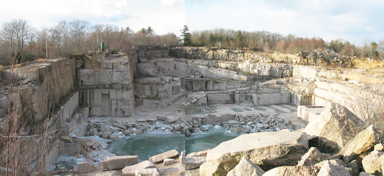
Stony Creek Quarry, Guilford. In operation since the1800’s, its pink granite was used inthe base of the Statue of Liberty and in the Sony Building in New York.
picking up after the glacier
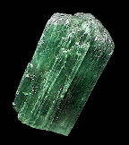
On a brisk winter morning when the stoic settler and his five strapping sons looked over their land and saw nothing but rocks their frustration must have been palpable. Where, in the name of Jedediah, do all these stones come from? Long before the settlers, long before the land as we know it, there was a time when Connecticut had a tropical climate. The eastern shore was part of Morocco, Antarctica was on the equator and Africa was the south pole. The shifting earth’s crust, tectonic plates, moving over millions of years at the speed of growing fingernails caused continents to collide and crumple like so much paper, then smooth out again as they drifted apart. The biggest crunch came 250 million years ago when Africa slammed into North America in a massive pile up of continents that produced the supercontinent Pangaea. It buckled up the Appalachian mountains, the European Alps, and in the midst of the melee, Connecticut was crushed to fraction of its size. But even Pangaea didn’t last, it drifted apart with the same wrenching effects to shape the world we are familiar with. To the keen eye evidence of the earth’s turmoil can be easily seen on the highways in the character of the rocks at the side of the road. Their color and contour are their history. Some are deep earth brown, some almost ochre or gray going black. They are layered in neat horizontals, sandwich-style, orsuddenly bucking inarabesque swirls, their stratified direction, dictated by pressure, switches north then south in dramatic contradictions, and often, just a few hundred yards further on there are rocks that look entirely different. The sound of the earth can be heard too. Moodus, from the Indian words – place of noises, sits on the edge of the Honey Hill fault, and was still giving out sighs and moans from the shifting Avalonia plate as recently as 1982. “It’s the east – west crushing and pulling,” Ralph Lewis energetically demonstrates with his hands as if playing the accordion, “that gave the bedrock its north – south ridges and valleys.” The youthful, retired, state geologist is a man who clearly loves his subject and relishes the chance to talk about Connecticut rock. He points out that if you drive east – west across the state you constantly go up hill and down dale, like crossing a corrugated roof the hard way. If you go north – south, though, you will probably remain in a valley. He steps outside to the terrace of his home and returns with an armful of rock samples. The higher Connecticut terrain is very hard, Metamorphic rock, he explains, meaning that it has been pummeled and reshaped by the earth’s movements. The striped rock is gneiss, pronounced ‘nice’, the stripes in it (foliation) are due to the mineral grains rearranging themselves under the immense heat and pressure. The rocks that look like compressed layers that could flake off in sheets are called schist. When Africa drifted away it pulled out the state like pizza dough before snapping off. The stretched out bit became the Connecticut Valley. Over time, in a monsoon like environment, it filled with Sedimentary rock – anaccumulation of weathered elements of soil and rock from the surrounding hills which settled and cemented together. It is the most boulder-free place in the state. Igneous rock is magma spewed from the earth that has cooled under varying conditions to give us rock like granite or traprock (roads, gravel), or obsidian (arrowheads and axes). The granules are evenly distributed not striped. The different kinds of rock left all over the state by the upheaval have been mined for centuries. The mantle of the White House East Room is made of Litchfield marble, many of the New York brownstone houses are built with Portland stone, which gets that reddish color from oxidation of iron in the sediment. Paving for New Orleans was shipped from Hadlyme, and many of the cobblestone streets of New York came from Selden Island, in Hamburg Cove. The Gillette quarry, a little further up the river from the castle, was one of the best known mineral deposits in the country. Gillette himself claimed to have sold tourmalines to a New York museum for $700 which was a great deal of money in those days. His quarry is closed now and inaccessible.
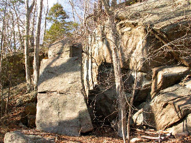
Egyptian Lotus supposedly found in the marshes on Selden Island in 1878 Selden Island is a state park and remains of the quarry are very clear: drill holes, rusted cables, foundations. In the 1890’s The Connecticut Valley Mining Company had an estimated six hundred men working steam drills, derricks and a small railroad to load schooners with as much as three thousand paving stones a day. Black powder was used to blow great sections off the rock face, which was then hauled down to the riverside in horsedrawn rail cars where it was shaped with chisels. The men, mostly Italians brought over especially for the job, lived in a long barracks on the island. These were tough customers and physical violence was an occupational hazard (the poet Rimbaud,when he worked in a Greek quarry, killed a man with a rock, which was why he fled to Ethiopia). With no easy way off Selden Island the men were virtually prisoners until the end of their contract. Bankruptcy ended the operation abruptly in 1903. At the farewell party a Sicilian cook with ‘Black Hand’ connections, signified by his unique brass belt-buckle, had a little too much vino, and boasted of having saved a small fortune. Eight years later hunters came across his remains including that infamous brass belt-buckle. The crime was never solved. If you don’t have access to a boat expeditions to the island are made by Riverquest and the Connecticut River Museum with guides who revel in the island’s history of quarrymen, hermits, counterfeiters and lilies in the marshes. A doctor from Essex apparently came across the lilies first in 1878. A purplish-pink flower standing 10 inches high off a giant lily pad. He took samples home with him and after research concluded it was the so called Egyptian Lotus, immediately causing speculation as to how it came to be in Selden cove. The Egyptian Lotus was supposed to have grown exclusively along the Nile at the time of the Pharaohs. The best hypothesis was that after the Civil War when cotton was in short supply, fabric was being brought from all over the world to paper mills up river. The time coincided with the plundering of many Egyptian tombs, and the selling of ancient fabric to ship captains who turned a blind eye to its origins. Perhaps buried in the folds of cloth were seeds of the Egyptian Lotus. It was supposed to flower every twenty-five years but the last claim to have seen it was in 1903. Apocryphal? Who can say? The landscape has been modeled by violent collision and erosion, but why, thinking of that weary settler and the thousands of miles of stone walls throughout New England, why are there so many small rocks? Glaciers, is Ralph Lewis’ emphatic answer. 26,000 years ago a mile high glacier crept down through Connecticut eventually reaching to the middle of Long Island. It stripped away all the top soil and all the rotten rock. Yes, rocks do rot given time. In places where the land has been weathered for millions of years you can find rocks that can be pulled apart with your bare hands. Rotten rock, is what eventually makes soil. As the glacier advanced south it pushed up over the hills rounding them off, in that north to south direction, some as smooth as a billiard ball, but as it moved on it took part of the hill with it. It’s called plucking. The ice, having frozen around the hill, literally plucked huge pieces of rock out of the south face and dragged them off. By about 15, 000 years ago the glacier had pretty much melted out of the state. The top soil had been pushed out, or flushed out by erosion, and the glacier had dumped the billions of once deeply buried rocks right on the surface. Some of those rocks stayed close to their source, they’re the sharper edged ones, the rounder rocks were in the glacial blender for some time. Others just rolled down the hill when glacier finally let go. How were the farmers to know? It wasn’t until 1806 that Benjamin Sillman made the first geological study of Connecticut, at that time geology was barely understood to be a science. When the west opened up and word got around that they had top soil twenty feet deep out there the farmers were gone. And the plates keep moving on. Which way are we going now? Hang on to your hat, we’re headed for California – but not any time soon.
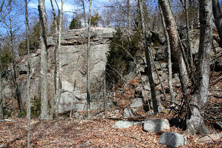
The glaciers literally ‘plucked’ off part of the hills as they moved over them
|
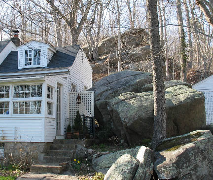
Living with rocksat your door
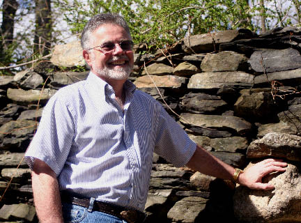
Ralph Lewis, former state geologist, on the steps leading up to Gillette’s Castle in front of an iapetos rock formation. Photograph by Emily Lewis
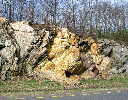
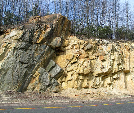
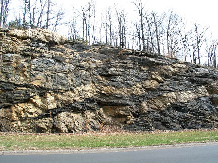
Color changes in the rocks along route 9
Evidence of the earth’s turmoil is clearly visible in the rocks along Route 9
Quarry on Selden Island The quarry face on Selden Island last mined in 1903.
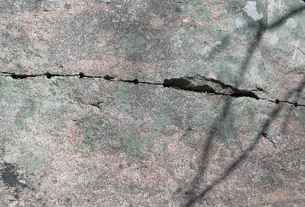
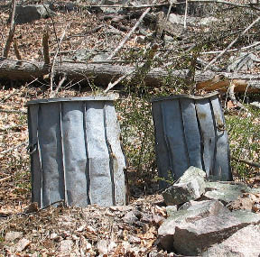
Hand drilled holes for wedges which will split the rock.Belowt: Buckets for
|